Munster Ridge Road Station
West Lake station area
Munster, Indiana
Last Updated: August 10, 2021
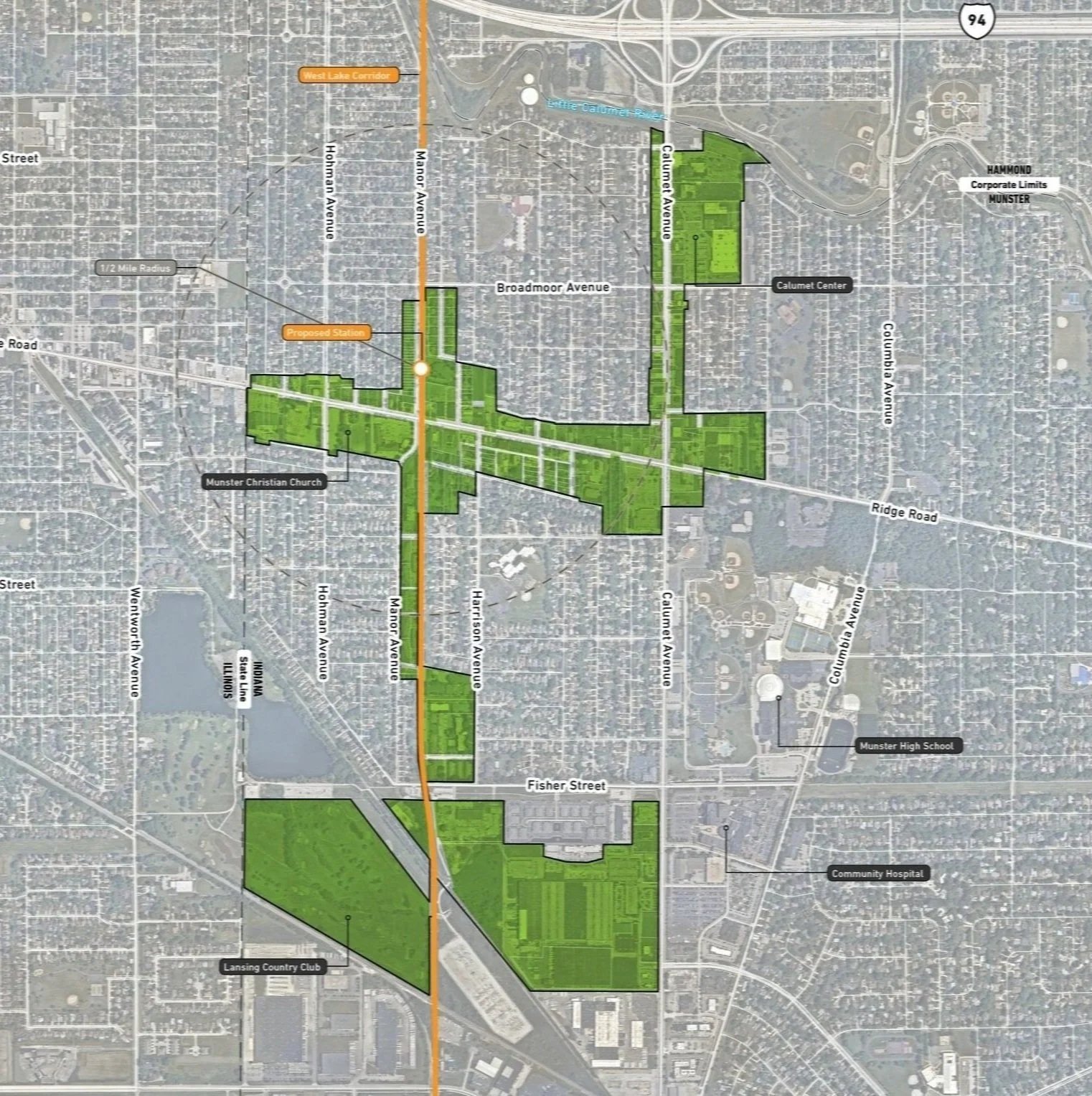
A Virtual Public Meeting for Munster Ridge Road was held on November 18th. A revised boundary based on public comment can be found below.
If you are interested in information for the Munster / Dyer Main Street Station, click here.
Station Area Summary
Introduction
The Ridge Road TDD is situated in a stable and highly walkable neighborhood with its historic commercial businesses along Ridge Road between the Indiana- Illinois State Line and Calumet Avenue. This station includes a modest parking area and is thought of mostly as a “kiss and ride” station. The town has been proactive in preparing for this station to be built and forthcoming investment, which sends a positive message to the development community. The town has completed a recent character-based zoning code (Town and Planning Design Collaborative) that provides appropriate TOD zoning. The town is also working on a complete streets project to improve the walkability and sense of place of along Ridge Road and Calumet Avenue.
TDD Boundary Summary
The resulting TDD boundary for the Munster Ridge Road station area focuses on three future investment strategies: Corridor, Neighborhoods, and Mixed-Use Town Center. The major commercial corridors of Ridge Road and Calumet Avenue present opportunities for strengthening the commercial environment around the station. The Monon Trail is a strong asset as a recreational corridor along the future West Lake Corridor. Because the station area is immediately adjacent to existing single-family neighborhoods, development should incorporate appropriately-scaled residential opportunities from the higher density adjacent to the proposed station to lower density that blends in with the neighborhood fabric. Mixed-use development could be concentrated where the rail line intersects with the Ridge Road that will support higher levels of activity associated with the station.
Community Priorities & Opportunities
Town of Munster Economic Goals
Promote sustainable growth - concentrate on strategic redevelopment areas
Support transit as critical to a prosperous town
Create a legacy of unique parks and open spaces
Grow as a hub of regional trail systems
Strengthen infrastructure to meet future needs
Redevelop old areas as walkable, mixed-use centers
Opportunity Analysis
Dense mixed-use development focused around the future station
Mixed-use infill/redevelopment along Ridge Road to complement existing commercial corridor
Trail connectivity from the station
Enhancement of Ridge Road and Calumet Avenue through streetscape design and traffic calming to attract private investment
Development Opportunities
Transit-oriented development opportunity for medium-density mixed-use exists around the immediate station area. Walkability should be enhanced to the station area from nearby traditional neighborhoods and commercial corridors. Multiple opportunity sites for mixed-use development also exist along Ridge Road. Development should be complementary to the existing walkable commercial area and residential neighborhoods around the station. Ridge Road and Calumet Avenue streetscape improvements have been planned and designed for these two important commercial corridors. The Munster community has the unique ability to attract multiple housing types near the station.
For a Full TDD Boundary Summary of Munster / Dyer Main Street Station, click here.
should all of this below be cut except the part on the public presentation ? ——>
Boundary Strategy
The process of developing the Ridge Road TDD boundary analyzed several existing characteristics of the station area. This analysis produced a step-by-step compilation of existing characteristics that illustrated a deeper understanding of the opportunities within the potential TDD boundary.
Due Diligence
The analysis required for creating the boundary focused on floodplains and flood zones; land use patterns, including community anchors (destinations such as schools, parks, city halls, churches, etc.), commercial areas and corridors, residential neighborhoods near these places of activity, agricultural or preserved land, industrial land, and vacant or underutilized and publicly-owned land; TIF Districts and Opportunity Zone boundaries; and previous planned areas or other areas of interest identified by the town. Locating land uses and destinations in the station area provides a sense of where generators of economic activity, community gathering, and employment opportunities currently exist in the community. Locating vacant or underutilized and publicly-owned land and other areas of interest helps identify sites that may have a low barrier to redevelopment or have already been considered for redevelopment by the town and suggest where future development and investment could occur.
Land Use
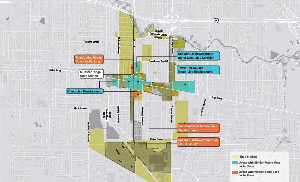
Existing land use patterns can inform opportunities for future investment that is compatible and complementary for the community. Major community anchors for the Munster Ridge Road station area included the Lansing Country Club, Town Hall, Munster Christian Church, the Monon Trail, and the Pennsy Greenway. Ridge Road and Calumet Avenue were identified as important commercial corridors, with the Calumet Center as a commercial node or destination. Clusters of residential areas exist along the Monon Trail to the south of Ridge Road and directly adjacent to the proposed station.
Vacant, Underutilized, and Publicly-Owned Land
There is little available vacant or underutilized land in the station area. The Town of Munster currently owns land adjacent to the station area, as well as the public works facility at Fisher Street and Town Hall on Ridge Road.
Town Plans and Areas of Interest
Previously planned areas include a re-envisioned Town Hall Square including Town Hall and the Calumet Avenue/Ridge Road intersection, the Lake Business Center redevelopment that includes the Public Works site, and the Lansing Country Club. Areas of interest identified by the town include a portion of Calumet Avenue, including Calumet Center, and a few sites around the proposed station.
For a Full TDD Boundary Summary of Munster / Dyer Main Street Station, click here.
Questions or Comments
Fill out a comment card - Contact Us
Check the FAQ section
Read through the questions below from the virtual public meeting
Browse through more information on the site which is constantly being updated
Virtual Public Presentation
See below for the full slide deck and video recording from the Virtual Public Presentation held on November 18, 2020:
Q&A
I thought the IN legislature passed legislation authorizing the RDA to use eminent domain for development projects.
The TDD legislation (IC 36-7.5-4.5 et seq) does not authorize use of eminent domain by the RDA.
Also TIF related to TDD allows revenue to go to other taxing districts.
Incremental revenue collected within individual boundaries must be reinvested within the same boundary. If TDD and TIF boundaries overlap, the RDA and local government would enter into a memorandum of agreement to determine how revenues are managed so that the TIF obligations are always met.
For those of us who live within the TDD boundary, will our taxes go up?
Establishment of the TDD boundary only allows the capture of incremental tax revenue. The TDD legislation does not authorize a new tax or levy.
What impact do you anticipate the project to have on existing businesses and residential properties within the TDD and TIF boundaries?
There is a tremendous opportunity to positively impact community growth, which enhances existing businesses and residential properties. Anticipated growth outcomes include new community-oriented development and new infrastructure such as streets, bridges, trails, and open space.
Does this overall plan include first mile/ last mile transportation, such as AV shuttles?
The effort is focused on establishing TDD boundaries will determine where incremental revenues can be collected and reinvested.


